

I see the following message from Nikos Koutras appearing on the Greek "Every Stork in Greece" Facebook page.
https://www.facebook.com/groups/EveryStorkinGreece/
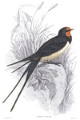
"Black Storks in the Pineios Delta.
Today I saw three of them in total."
What a beautiful storklet !

© Nikos Koutras, photography
Udu was last night at the same river, the Pineios, but not at its estuary, rather towards its source.
So s/he is not the only juvenile BS who is (still) in that area...
Maybe the Pineios Delta would be a good wintering site?
The Pineios creates a large delta, well known for its beauty and for many animal species, protected by international environmental treaties. Wikipedia

https://goo.gl/maps/U5RQLV6HCk938pNm9

https://goo.gl/maps/QkuvfSV4VGD29VRk7
BirdLife international Data Zone
Pineios delta: IBA Criteria met: A1, C1 (2000)
Site description: The site contains a variety of wetland and drier habitats including riverine and coastal woodland, sand-dunes, lagoons, saltmarsh and freshwater marsh.
Key biodiversity: An important site for wintering and passage waterbirds.
http://datazone.birdlife.org/site/facts ... iba-greece


