Following Karls' Families

Migration Maps, Tõnn, Greater Spotted Eagle and Black Storks
Post Reply
User avatar
sova
Registered user
Posts: 29371
Joined: October 14th, 2015, 7:11 pm

Re: Following Karl's Family

Post by sova »

visit wrote: August 12th, 2019, 8:22 am What is the difference between these two links for Orus migration ?
http://birdmap.5dvision.ee/en
and
https://www.google.com/maps/d/viewer?mi ... 32905&z=12
it is a little irritating...
Visit ... :hi:
http://birdmap.5dvision.ee/en is updated by Mr. Urmas (if he does not have time, not every day)
It's the place, therefore, Kilommeter - story of the bird to read).

https://www.google.com/maps/d/viewer?mi ...
This card is made by members (only have few access to this data).
Data comes in twice a day. We always have the latest data and are not dependent on Mr. Urmas.

So, I hope I explained it understandably (GT)
Solo
Registered user
Posts: 23861
Joined: October 19th, 2015, 7:18 pm

Post by Solo »

:hi: Juta, thanx :2thumbsup:
juta wrote: August 12th, 2019, 8:52 am Image
Ganukrogs area (https://lv.wikipedia.org/wiki/Ganukrogs)

Image

Image

street view is only from bus station area - main road (enough far): https://goo.gl/maps/ghQSPKnsiQNJHeff9
Treia
Registered user
Posts: 567
Joined: August 11th, 2018, 9:42 am
Location: Finland

Post by Treia »

:wave: Hellou all together !

Thanks JoUK for your response to my wish!!!

Great to have BirdMap open for the new season, thanks!!!
There you can see that...
Karula's last data is 11.08.2019, distance 271 km
Oru's last data 12.08.209, distance 153 km

Furthermore I would hope, if possible, that we could get a small picture in BirdMap of Aru, Oru, and Karula,
and if possible, it would be nice if the texts of Eedi and Karula could be slightly supplemented? It would be great! :D
User avatar
juta
Site Admin
Posts: 5732
Joined: September 25th, 2008, 1:52 pm
Location: Tallinn, Estonia

Post by juta »

Treia, Birdmap is done by Urmas and by hand!
Please try yourself to look around in the menu (up on the left). You can choose only one or several birds. If you click on bird´s name, you get the info if available.
Proud member of SHoW (StorkaHolics of the World)
visit
Registered user
Posts: 256
Joined: May 2nd, 2019, 11:13 am
Location: Germany

Post by visit »

Thank you sova !
I see, that's the reason why the data are different :)
Solo
Registered user
Posts: 23861
Joined: October 19th, 2015, 7:18 pm

Post by Solo »

ORU

Last data: 11.08.2019, Distance: 151 km
New data: 12.08.2019, Distance: 153 km - plus 2km (maybe morning on the way)

direction Produsala - Krustpils Parish, Krustpils Municipality in Latgale, Latvia

Image

Image

a view of the area where Oru flies from the road junction:

Image
https://goo.gl/maps/uRW169VkJrZ8iEP5A
Treia
Registered user
Posts: 567
Joined: August 11th, 2018, 9:42 am
Location: Finland

Post by Treia »

juta wrote: August 12th, 2019, 11:33 am Treia, Birdmap is done by Urmas and by hand!
Please try yourself to look around in the menu (up on the left). You can choose only one or several birds. If you click on bird´s name, you get the info if available.
:wave: Ok thanks thanks juta!
I know, but maybe and hopefully he would have time at some point make small additions!
User avatar
Poliff
Registered user
Posts: 140
Joined: June 22nd, 2019, 4:34 pm

Post by Poliff »

Hi everyone! Please tell me -
Image
is the altitude of the place or its flight?
Smile, you're being filmed by a hidden camera!
Solo
Registered user
Posts: 23861
Joined: October 19th, 2015, 7:18 pm

Post by Solo »

Poliff wrote: August 12th, 2019, 12:11 pmHi everyone! Please tell me - is the altitude of the place or its flight?
Poliff, Anne maybe know the answer or anyone else remember too (Urmas wrote here about this - to situation with Päike in autumn 2018)

I read "flight altitude" (above the land)
resp. OrniTrack transmitters "says":
Main data record includes: UTC date & time, GPS position, GPS altitude, speed, direction, HDOP, battery voltage, battery charging current, instant acceleration (3 axes), ambient light intensity, temperature, magnetic field strength (3 axes)

EDIT:
by Urmas: "height value probably not that much of the GPS device" (https://www.looduskalender.ee/forum/vie ... start=1500)
by Urmas: (now I am not able to find the second comments by Urmas to this)
Summi
Registered user
Posts: 3327
Joined: September 14th, 2009, 11:54 am
Location: Estonia

Post by Summi »

Thank you Juta and Anne :wave:
Our little Oru is on the way. May you have favorable winds under the wings and fresh fish in abundance. And please remember - you aren't alone, your fans will follow every step of yours.
:loveshower:
Jo UK
Site Admin
Posts: 20707
Joined: September 20th, 2008, 1:40 am
Location: Winchester, UK

Post by Jo UK »

Poliff wrote: August 12th, 2019, 12:11 pm Hi everyone! Please tell me -
is the altitude of the place or its flight?
Hi, poliff.
I have wondered the same but not yet made the effort to find the answer. I suppose it could be done by going to that location on Google Earth and seeing the elevation as recorded there. If you do that, please post the answer here. I would like to know too.
Solo
Registered user
Posts: 23861
Joined: October 19th, 2015, 7:18 pm

Post by Solo »

Summi wrote: August 12th, 2019, 12:38 pmThank you Juta and Anne Our little Oru is on the way. ...
Summi - to me no thanks? :unsure:
User avatar
Poliff
Registered user
Posts: 140
Joined: June 22nd, 2019, 4:34 pm

Post by Poliff »

Jo UK wrote: August 12th, 2019, 12:38 pm Hi, poliff.
I have wondered the same but not yet made the effort to find the answer. I suppose it could be done by going to that location on Google Earth and seeing the elevation as recorded there. If you do that, please post the answer here. I would like to know too.
This is the height above sea level of the place itself.
I found only such a map where you can see the height. Sorry.
Image

Image


And since our Oru stood still, it is definitely the height of the place.
Smile, you're being filmed by a hidden camera!
User avatar
Poliff
Registered user
Posts: 140
Joined: June 22nd, 2019, 4:34 pm

Post by Poliff »

However, in another case, the height of the label = 138m above sea level, but on the map the label Oru is at an altitude of 156m. At the same time it has a speed of 43 km/h. Which leads us to the conclusion that we still see the height of the transmitter above sea level.
Image

Image
Smile, you're being filmed by a hidden camera!
Jo UK
Site Admin
Posts: 20707
Joined: September 20th, 2008, 1:40 am
Location: Winchester, UK

Post by Jo UK »

If the transmitter was at sea level then it should show 0 meters.
From the numbers given in that example I would think that ground level is 138 metres but Oru is at 156 metres, therefore he is 18 metres above ground level.
Is it so?

On the other hand, last year Urmas wrote -
- but height value probably not that much of the GPS device
User avatar
Anne7
Registered user
Posts: 10569
Joined: April 15th, 2016, 3:26 pm
Location: Belgium

Post by Anne7 »

Poliff wrote: August 12th, 2019, 12:11 pm Hi everyone! Please tell me -
Image
is the altitude of the place or its flight?
Hello Poliff :wave:

In the OrniTrack User Manual is written:
"Altitude_m = GPS measured altitude above mean (average) sea level, in meters"

So 
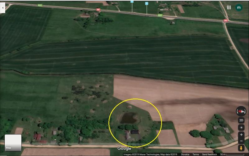
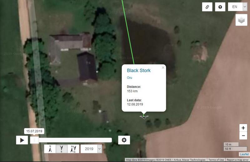
the tracker map indicates the height of the bird above sea level (in meters).
(And this at every listed location.)

The term "above sea level" generally refers to above mean sea level.
Mean sea level (MSL) (often shortened to "sea level") is an average level of the surface of one or more of Earth's bodies of water from which heights such as elevation may be measured.
Precise determination of a "mean sea level" is difficult to achieve because of the many factors that affect sea level.
Jo UK wrote: August 12th, 2019, 1:45 pm ...On the other hand, last year Urmas wrote -
- but height value probably not that much of the GPS device
:nod: The height that GPS is able to measure is rather approximate. Not accurate to the meter.
I do not know how large the possible "margin of error" is, in the height indication. (20-25 m at most, I think)

If you want to know how high the bird is flying above the ground, you should indeed subtract the exact height of the location from the height of the bird (as shown in the tracker map). That will only be an approximation.
“Clearly, animals know more than we think, and think a great deal more than we know.”
— Irene Pepperberg
Jo UK
Site Admin
Posts: 20707
Joined: September 20th, 2008, 1:40 am
Location: Winchester, UK

Post by Jo UK »

Thanks, Anne.
I was trying to find the bird's height above land but Google earth isn't helping me!
Summi
Registered user
Posts: 3327
Joined: September 14th, 2009, 11:54 am
Location: Estonia

Post by Summi »

Solo wrote: August 12th, 2019, 12:43 pm Summi - to me no thanks? :unsure:
I'm sorry, Solo. Now I see so many posts from many members but when I posted my comment saw only a couple. It must have been because I sent my post basing on the link that was given in Karula Forum and it led me to the page where couldn't see all the posts.
I deeply regret for the misunderstanding and thank everyone who had posted before and whom I didn't mention personally.
:blush:
visit
Registered user
Posts: 256
Joined: May 2nd, 2019, 11:13 am
Location: Germany

Post by visit »

btw i thought Oru is (just out of the nest) already sometimes quite high: Altitude 861 meters
will later have a look if somewhere is something written about the highest highs...
User avatar
Poliff
Registered user
Posts: 140
Joined: June 22nd, 2019, 4:34 pm

Post by Poliff »

Jo UK wrote: August 12th, 2019, 1:45 pm If the transmitter was at sea level then it should show 0 meters.
From the numbers given in that example I would think that ground level is 138 metres but Oru is at 156 metres, therefore he is 18 metres above ground level.
Is it so?

On the other hand, last year Urmas wrote -
- but height value probably not that much of the GPS device
I gave two examples specifically to show that the tags show the altitude for the transmitter and it doesn't matter sitting or flying the Oru. A meter of flight above ground level, we can only count by subtraction. The total error of such transmitters is about 7-10 meters and other data on heights is what I know from the employees of our reserve.
Smile, you're being filmed by a hidden camera!
Post Reply

Return to “Migration Maps and News”