Following Karls' Families

Migration Maps, Tõnn, Greater Spotted Eagle and Black Storks
Post Reply
Solo
Registered user
Posts: 23861
Joined: October 19th, 2015, 7:18 pm

Re: Following Karl's Family

Post by Solo »

yitmoth wrote: August 13th, 2019, 3:13 pmNever mind. Thanks for the clarification, Solo. :wave:
yitmoth you're welcome

pls, about migration here is the right topic/palce, thanx :wave:
User avatar
Anne7
Registered user
Posts: 10569
Joined: April 15th, 2016, 3:26 pm
Location: Belgium

Post by Anne7 »

visit wrote: August 13th, 2019, 1:43 pm i'm sorry, but i have to ask once more:

i've now 3 links for Oru in the google map isn't it any more possible to add the old data in the newest map too ?
all data up from the start in 1 map would be great !
visit wrote: August 13th, 2019, 2:33 pm oh - comprehension question:
so you can "only" put the data of two days in one map ? right ?
thought i've seen such map(s) of older storks with much more days :puzzled:
Visit :hi:

Twice a day the bird sends (via GPRS) all data that its transmitter has collected (via satellite), as well as all info that the built-in sensors of his transmitter collected.
The (by OrniTrack) received raw data is twice a day converted (by three people who have access) into an interactive (clickable) and very detailed tracker map. What interests us in these tracker maps is the current (recent) behaviour of the bird. Where did he sleep? Where did he feed? How fast and how high did he fly? How close did he come to human settlements? How long did he stay in the same place? Is there anything that could indicate that the bird is in trouble? Is the transmitter battery still working properly? Etc...
It is theoretically possible to put all data from the entire migration in 1 tracker map.
But including all these data from all previous days, weeks, months or even years, in each and every new tracker map, would make the tracker maps extremely heavy, and in the long run very unclear.


On birdmap, you can permanently see the complete (but simplified) route (per season) of each tracked bird. Plus the flown distance.
There is a scroll bar on birdmap. There you can see where the bird was on which day, although this info is not 100% accurate.

Oru's route on birdmap, so far:
Image
“Clearly, animals know more than we think, and think a great deal more than we know.”
— Irene Pepperberg
User avatar
Poliff
Registered user
Posts: 140
Joined: June 22nd, 2019, 4:34 pm

Post by Poliff »

Please tell me. I did not understand, if you open the map on the links and update them every day, I will not see the movement on them? At the moment I do not see updates on those maps that are already open.
Smile, you're being filmed by a hidden camera!
visit
Registered user
Posts: 256
Joined: May 2nd, 2019, 11:13 am
Location: Germany

Post by visit »

Hello Anne,

and thank you very much for the explanations ! :))
Anne7 wrote:It is theoretically possible to put all data from the entire migration in 1 tracker map.
But including all these data from all previous days, weeks, months or even years, in each and every new tracker map, would make the tracker maps extremely heavy, and in the long run very unclear.
Ah, that's it ! :)
i see. so how many days (or data sets) are you usually putting in one map ?
You seem to have done it for a longer time already and surely have tried out how much is possible or recommended ?

Thanks for the huge work !! :)
User avatar
Anne7
Registered user
Posts: 10569
Joined: April 15th, 2016, 3:26 pm
Location: Belgium

Post by Anne7 »

Poliff wrote: August 13th, 2019, 4:28 pm Please tell me. I did not understand, if you open the map on the links and update them every day, I will not see the movement on them? At the moment I do not see updates on those maps that are already open.
Poliff :wave:
It's not possible to "update" an existing link.
Each new tracker map has its own, new link.
visit wrote: August 13th, 2019, 4:34 pm Ah, that's it ! :)
i see. so how many days (or data sets) are you usually putting in one map ?
You seem to have done it for a longer time already and surely have tried out how much is possible or recommended ?
Thanks for the huge work !! :)
Personally, I like to see 1 complete day in a tracker map. It seems to be the easiest to understand and the most uncluttered. The first blue square is the position early in the morning (night), the last dot (the white arrow) is the last known position in the evening.
In some cases, it is of course not possible to show a whole day. Sometimes no new data comes in (= data session on OrniTrack failed). And in a morning update, obviously, we only see the last transmitted position of that morning.
“Clearly, animals know more than we think, and think a great deal more than we know.”
— Irene Pepperberg
Jo UK
Site Admin
Posts: 20707
Joined: September 20th, 2008, 1:40 am
Location: Winchester, UK

Post by Jo UK »

Tracker map for Karula from August 11, 23.55 to August 13, 13.10

Tracker Map
KARULA

https://drive.google.com/open?id=1ZR66R ... sp=sharing


Oru's tracker map will be ready at about 18.00 UK time (20.00 Estonian time)
User avatar
Anne7
Registered user
Posts: 10569
Joined: April 15th, 2016, 3:26 pm
Location: Belgium

Post by Anne7 »

Thanks, Jo! :hi:

Image

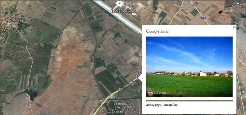
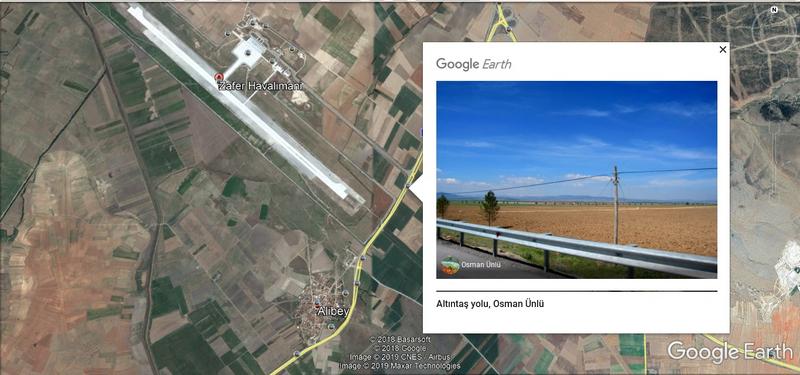
Little KARULA flew back to the Zafer Airport.
He flew over the runway. Be careful, Karula!
Image
“Clearly, animals know more than we think, and think a great deal more than we know.”
— Irene Pepperberg
User avatar
sova
Registered user
Posts: 29371
Joined: October 14th, 2015, 7:11 pm

Post by sova »

Hello everyone :hi:

Anne .... Karula's weather data is available
Wish you all a nice evening
User avatar
Anne7
Registered user
Posts: 10569
Joined: April 15th, 2016, 3:26 pm
Location: Belgium

Post by Anne7 »

sova wrote: August 13th, 2019, 5:25 pm Hello everyone :hi:
Anne .... Karula's weather data is available
Wish you all a nice evening
Many thanks, Sova. :wave:
I'll make the summary.

Edit:
There has been a late birdmap update for Karula. (Thanks, sova)

Image


TODAY'S SUMMARY AUGUST 13

KARULA (Hatched 2018)
Birdmap was set to spring migration and the new distance measurement started on 15.02.2019
(Total distance on 14.02.2019 = 6606 km)

Birdmap was set to autumn migration on 11.08.2019 and the new distance measurement started on 15.07.2019
(Total distance on 14.07.2019 = 3012 km)
Overall flown distance until 14.07.2019 = 9618 km

Last data: 13.08.2019
Distance: 417 km (+ 39 km in 1 day), near Nuhören in Turkey
Weather report on 13.08 in Kütahya Zafer Airport at 10:00
Temp 2 m above the ground: 26°
Temp 500 m above the ground: 28°
Precipitation: 0 mm
Humidity: 20%
Air pressure: 1011 hPa
Wind 100 m - E (16 km/h)
Wind 250 m - E (17 km/h)
Wind 500 m - E (18 km/h)
Weather report on 13.08 in Kütahya Zafer Airport at 15:00
Temp 2 m above the ground: 33°
Temp 500 m above the ground: 35°
Wind 100 m - E (12 km/h)
Wind 250 m - E (13 km/h)
Wind 500 m - E (10 km/h)

ORU (Hatched 2019)
Oru started his first migration on 10.08.2019.
First update
New data: 13.08.2019 (morning)
Distance: 251 km (+ 3 km), near Medeikiai, Lithuania.
Second update:
New data: 13.08.2019 (data recieved on 14.08)
Distance: 420 km (+ 169 km on the same day), near Milžinai, Lithuania
“Clearly, animals know more than we think, and think a great deal more than we know.”
— Irene Pepperberg
User avatar
Poliff
Registered user
Posts: 140
Joined: June 22nd, 2019, 4:34 pm

Post by Poliff »

Anne7 wrote: August 13th, 2019, 4:40 pm Poliff :wave:
It's not possible to "update" an existing link.
Each new tracker map has its own, new link.
That is, every time you need to wait for someone to post an updated link?
But the birdmap can be updated and there will be new lines.

I specifically specify. To stop asking questions like that. TU :nod:
Smile, you're being filmed by a hidden camera!
Solo
Registered user
Posts: 23861
Joined: October 19th, 2015, 7:18 pm

Post by Solo »

Poliff wrote: August 13th, 2019, 5:40 pmThat is, every time you need to wait for someone to post an updated link? ...
someone = our Anna :headroll:
User avatar
Poliff
Registered user
Posts: 140
Joined: June 22nd, 2019, 4:34 pm

Post by Poliff »

Solo wrote: August 13th, 2019, 5:46 pm someone = our Anna :headroll:
Thanks so much :shake:
Smile, you're being filmed by a hidden camera!
Hellem
Registered user
Posts: 24158
Joined: June 28th, 2012, 4:33 pm
Location: Tallinn

Post by Hellem »

Poliff wrote: August 13th, 2019, 5:40 pm That is, every time you need to wait for someone to post an updated link?
:wave: Yes, and patiently :laugh:
Solo
Registered user
Posts: 23861
Joined: October 19th, 2015, 7:18 pm

Post by Solo »

visit
Registered user
Posts: 256
Joined: May 2nd, 2019, 11:13 am
Location: Germany

Post by visit »

Anne7 wrote:I personally like to see 1 complete day in a tracker map. It seems to be the easiest to understand and the most uncluttered. The first blue square is the position early in the morning (night), the last dot (the white arrow) is the last known position in the evening.
In some cases, it is of course not possible to show a whole day. Sometimes no new data comes in (= data session on OrniTrack failed). And in a morning update, obviously, we only see the last transmitted position of that morning.
Oh !
so about 365 links per year (instead e.g. 52 links).
ok - now i've touching to understand your system :)

and the links of each storklet are here in this thread ?
only for one year that it won't become a big mixup or how... ?
*have seen Maru etc for example
Solo
Registered user
Posts: 23861
Joined: October 19th, 2015, 7:18 pm

Post by Solo »

KARULA

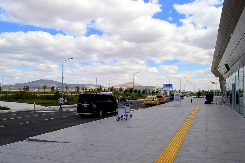
https://www.wikiwand.com/en/Zafer_Airport
"The airport's runway is 3,000 m (9,800 ft) long and 45 m (148 ft) wide. The airport ramp allows parking of five aircraft at the same time."

the wider area - Karula flew over the runway
Image
By CeeGee - Own work, CC BY-SA 4.0, https://commons.wikimedia.org/w/index.p ... d=42700191

(more photos e.g. https://commons.wikimedia.org/wiki/Cate ... er_Airport)

Image
http://www.icholding.com.tr/EN/altyapi/ProjeDetay/17

Image
google earth, by hasmet sis
https://lh5.googleusercontent.com/p/AF1 ... QbF66=h720
Solo
Registered user
Posts: 23861
Joined: October 19th, 2015, 7:18 pm

Post by Solo »

visit wrote: August 13th, 2019, 6:00 pm...and the links of each storklet are here in this thread ?
only for one year that it won't become a big mixup or how... ? *have seen Maru etc for example
1/ here = topic "Following Karl's Family" - informs about inhabitant the nest in Karula NP: Karl's and Katie's nest (now about Karula, storklet hatched 2018 and Oru, storklet hatched 2019 in this nest)

2/ topic "Black Stork Tracks" informs:
- first about storks from Estonia: Raivo (perished), Eedi (alive) and Karl I (perished) also here
- later about storklets from Latvia (also from nest without streaming - nowadays only Mare is still alive)
- not regularly also about tagged storks from Poland (storklets), Hungary (adult male BS), etc. (and/or in thread "Black Stork Nests in Europe")

big mix :mrgreen:
visit
Registered user
Posts: 256
Joined: May 2nd, 2019, 11:13 am
Location: Germany

Post by visit »

hm, ooookeyyyy :))

Thx again ;)

:headroll:
User avatar
Anne7
Registered user
Posts: 10569
Joined: April 15th, 2016, 3:26 pm
Location: Belgium

Post by Anne7 »

Poliff wrote: August 13th, 2019, 5:40 pm That is, every time you need to wait for someone to post an updated link?
But the birdmap can be updated and there will be new lines.

I specifically specify. To stop asking questions like that. TU :nod :
Poliff, :hi:
Urmas updates the birdmap. To do that, he also uses the raw data that is received (if all goes well) on OrniTrack. He will do that work at a moment when he has time. So sometimes not every day. For example, if he is abroad, you will have to wait many days.

Jo, Juta and I make the tracker maps. That is not an automated process. It takes quite some work and concentration to create such maps + pictures of the maps + street views. We are volunteers, and neither of us can afford to be permanently available, each and every day. So yes, you will have to wait. :D
Firstly, until there has been a new successful data session on OrniTrack.
Secondly, until one of us has enough time (and willingness) to create the new tracker maps.
:wave:
visit wrote: August 13th, 2019, 6:00 pm Oh !
so about 365 links per year (instead e.g. 52 links).
ok - now i've touching to understand your system :)
for example
Visit, for the 3 birds together it will be 365 x 3 = 1095 tracker-map-links per year.
And if we make 2 tracker maps per day for each of the three storklets (Karula, Oru and hopefully soon also Aru), it will even become 2190 tracker maps. :mrgreen:

Good heavens, now that I calculated it, I am startled by this number ... and the amount of work! :D
“Clearly, animals know more than we think, and think a great deal more than we know.”
— Irene Pepperberg
Jo UK
Site Admin
Posts: 20707
Joined: September 20th, 2008, 1:40 am
Location: Winchester, UK

Post by Jo UK »

Anne, that is a frightening number -1095 tracker maps. Heavens. How much time will that take each day, each week, all year? :shock:

Anyway, here is my small (5 minutes) contribution for this evening. I didn't notice how long it took to make Karula's map this afternoon.

Tracker map for Oru from August 12. 02.07 to August 13. 16.35

Tracker Map
ORU

https://drive.google.com/open?id=1lKpoC ... sp=sharing
Post Reply

Return to “Migration Maps and News”